
Bihar Flood Alert: Gandak River Embankment Breach Floods East Champaran; CM Conducts Aerial Survey
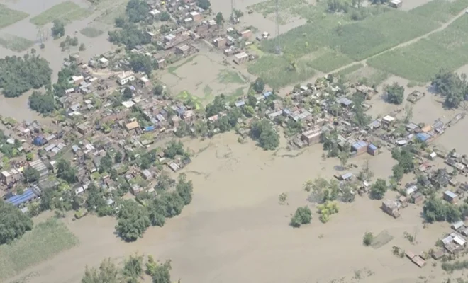
Bihar finds itself in an increasingly desperate flood situation because of the continued presence of the Gandak River above the danger mark at multiple gauging stations, embankment breaches causing floods in the Champaran district and other districts along the Gandak. High rains in the Gandak catchment area of Nepal have caused floods.
This has led the Chief Minister of Bihar, Samrat Choudhary, to undertake an aerial survey of the affected areas to assess the situation regarding the relief and rescue operation. The most worrisome part about the current development is that of East Champaran, where floodwaters from the Gandak breached the ring bund.
What Caused the Bihar Flood Situation?
The immediate cause was excessive rainfall in the catchment region of the Gandak River located in Nepal. The excessive and sudden rain led to increased flow of water into Bihar state downstream, exerting pressure on the embankments and other flood management infrastructure.
According to the Bihar Water Resources Department, the Valmikinagar Gandak Barrage registered a discharge of 5,43,500 cusecs at 6 am on September 29. For 13 hours, the discharge remained above 5 lakh cusecs, and for 32 hours, it remained above 4 lakh cusecs, putting immense pressure on the downstream areas.
The water level at the Bagaha gauge of the Gandak River also touched an all-time record of 91.25 metres, surpassing the previous record-high water level of 90.90 metres established in 2024.
East Champaran Faces Severe Flooding
East Champaran has become one of those places that are having tough times due to the rising level of Gandak. It is reported that a ring bund that was meant to protect the area near Sareya Pandit Tola of Areraj was broken down on September 29, causing water to enter nearby villages.
According to reports from the area, many low lying portions of Nawada, Mashraulia and Sareya Panchayats are inundated with water up to several feet in height. Water has entered houses and farms, along with causing disruption to local connectivity, where vulnerable communities have shifted to their rooftops for safety.
The floods have also raised concerns of water for drinking and fodder for animals.
How Wide Is the Flood Impact?
The flood warning issued for Bihar is not limited to East Champaran only. The rising level of the Gandak has led to floods in other downstream districts such as West Champaran, Gopalganj, Saran, Muzaffarpur, and Vaishali.
As per the official data released by the state government on 1st October regarding the flood situation in the state, the level of the Gandak river has been reported to be above danger mark in Chatia in East Champaran, Bagaha and Thakraha in West Champaran.
What Did Chief Minister Samrat Choudhary Do?
Samrat Choudhary, the Bihar Chief Minister undertook a flight survey of flood affected areas as the Gandak condition worsened. Choudhary conducted a flight survey on September 30 in areas like Bagaha, Bathna, Machhargawan, Shivrajpur, and Bankatwa in West Champaran apart from checking the broken embankment of the Gandak in Haizalpur in Saran.
In his previous visit, Choudhary had taken note of the condition in East Champaran, Gopalganj, Vaishali and Saran along with visiting the Gandak in Dumariaghat. The officials informed him about the river level being almost 1.5 metre above the danger level at the time.
What Relief Measures Are Underway?
Teams have been sent by the authorities to restore embankment and perform urgent protection. The administration has also been directed to conduct surveillance of vulnerable areas such as embankment areas even during nighttime.
Food is being provided through relief camps and community kitchens to the affected people. Disaster relief organizations such as SDRF and NDRF teams have been involved in relief and rescue efforts in the affected areas.
In East Champaran, it has been reported that boats have been employed where there is loss of road connectivity and distribution of dry food and other supplies like tarpaulins is going on.
Is the Gandak River Level Falling?
However, there are conflicting signals based on the geographic position. According to the Water Resources Department, there was a decline in water levels at Valmikinagar Barrage past the peak flood flow since the downstream discharge fell to 1,91,200 cusecs in their Tuesday morning bulletin. However, rising waters may continue to be experienced downstream for some time even after upstream water levels have started declining due to the lag time for the flood wave to propagate down the river.
Flood monitoring figures from October 1 show that there are still several Gandak sites that are over the danger level and some have surpassed their highest flood levels.
This implies that the Bihar flood warning cannot be considered over just because the upstream water levels have started declining.
Why the Situation Remains Serious
The fact that the river is flowing at unprecedented levels along with the damage to embankments and floods in several districts has made the task all the more difficult. Agricultural lands have been flooded; local transportation has been affected and the affected communities still rely on emergency help in certain places. The Indian Express
Monitoring the Gandak river therefore remains important, especially for the communities in low-lying areas below the major breach point.
What Should the Citizens Do?
Citizens living in flood-prone or low-lying areas should obey instructions given by the district authorities and evacuate to the relief camps if evacuation orders are given. People should not enter into the rapidly flowing water and should not cross over flooded roads and bridges.
Citizens should also ensure that they have all the essentials available with them in case of any evacuation.
Conclusion
The situation regarding the Bihar flood has worsened due to the heavy rains that fell in Nepal causing huge floods in the Gandak river system. Breaches in embankments and ring-bunds have caused flooding in parts of East Champaran district as well as other districts, while official measurements have indicated that the level of the river is still above the danger mark at various points.
The chief minister of Bihar, Samrat Choudhary’s aerial survey and the directives for continuous monitoring of embankments, rescue efforts, and distribution of relief material highlight the gravity of the situation. Though there have been indications of reduction in water levels in some areas upriver, there are still risks for downstream regions due to continued movement of floodwater.
While the water levels of the Gandak River have started reducing at certain points, the Bihar flood warning still holds significance for East Champaran and other downstream regions.
Stay Updated on India’s Weather and Flood Risks
What Are Pilgrimage Routes Facing Alerts?
Check out the latest travel warnings for mountain corridors amid heavy rains.
Why Does Bihar Oppose Farakka Treaty?
Find out how the treaty affects Ganga water and siltation concerns.
Which States Face Heavy Rainfall Risks?
Uncover the seven states preparing for possible floods and disruptions.
Which States Face Severe Rain Alerts?
Browse the IMD’s latest warnings covering 20 states over 24 hours.
What Caused The Chamoli Tunnel Disaster?
Dive into the landslide and sudden water inflow that caused seven deaths.